|
|
本帖最后由 ygsj24 于 2025-8-14 18:00 编辑
403
WTNT45 KNHC 140846
TCDAT5
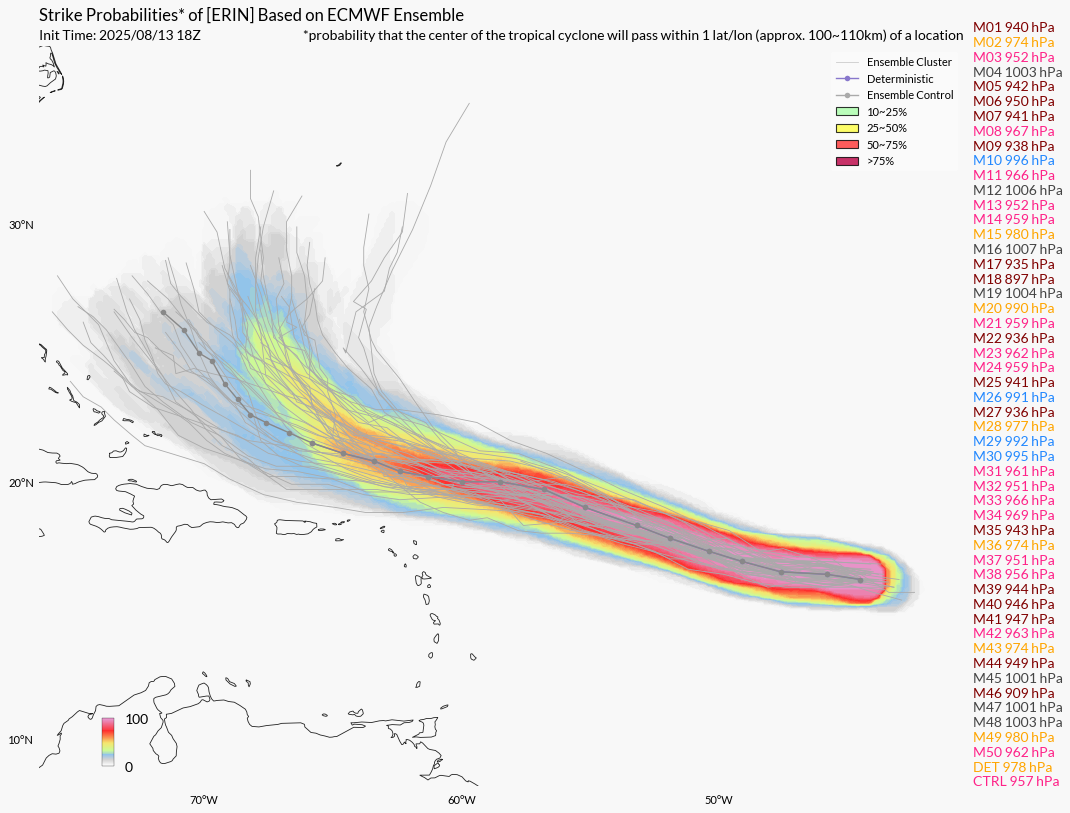
Tropical Storm Erin Discussion Number 12
NWS National Hurricane Center Miami FL AL052025
500 AM AST Thu Aug 14 2025
Satellite imagery shows that Erin continues to produce an area of
deep convection, with the center estimated to be on the northeastern
side of the convective shield. There has not been much change since
the previous advisory, and there has been no recent microwave
imagery to assess the overall structure. However, TAFB noted a
slight increase in the curved banding with the latest data-t
value. Subjective satellite current intensity estimates have held
steady around 45 kt, and objective satellite estimates from UW-CIMSS
range from 39 to 51 knots, with a satellite consensus of 46 kt.
Using a blend of these estimates, the intensity is held at 45 kt for
this advisory.
The overall environment around Erin is conducive for gradual
strengthening during the next day or so. Thereafter, the system is
forecast to move across warmer waters, and the GFS and EC SHIPS
guidance suggests a slight decrease in shear. This increasingly
favorable environment could result in a period of rapid
intensification, which is explicitly forecast between 24-48 h. Wind
shear may slightly increase later this weekend, although sea surface
temperatures remain around 29C, with favorable divergence aloft.
Most of the intensity guidance continues to show strengthening at
this time frame just at a steady rate, with Erin forecast to become
a major hurricane by day 3. The NHC intensity forecast is similar to
the previous and lies closest to the HCCA corrected consensus, there
are some models, such as the FSSE, that depict a higher intensity by
the end of the forecast period than the current NHC forecast. There
continues to be confidence that Erin will be a large and powerful
hurricane over the southwestern Atlantic Ocean this weekend.
Erin continues to move westward at an estimated motion of 270/15 kt.
The storm is being steered by a subtropical ridge to the north,
and the system should gradually turn more west-northwestward later
tonight, with this motion anticipated into the weekend. A weakness
in the ridge is forecast to develop early next week, resulting in a
turn towards the northwest or north-northwest. The guidance is
fairly tightly cluster through day 3, with some slight along-track
spread on the turn toward the northwest. Beyond day 3, the GFS and
Google DeepMind are on the eastern edge of the guidance, and the
hurricane regional models on the western side. The latest NHC
forecast is similar to the previous and lies near the consensus
aids. There is still a greater than normal uncertainty about what
impacts Erin may bring to portions of the Bahamas, the east coast of
the United States, and Bermuda in the long range.
KEY MESSAGES:
1. Locally heavy rainfall, high surf and rip currents, and
tropical-storm force winds could occur in portions of the northern
Leeward Islands, the Virgin Islands, and Puerto Rico this weekend as
the core of Erin passes north of those islands. Interests in these
areas should continue to monitor the progress of Erin.
2. While there is still uncertainty in what impacts might occur in
portions of the Bahamas, the east coast of the United States, and
Bermuda next week, the risk of dangerous surf and rip currents
across the western Atlantic basin next week is increasing. As we
approach the climatological peak of the hurricane season, this is an
opportune time to ensure your preparedness plans are in place.
FORECAST POSITIONS AND MAX WINDS
INIT 14/0900Z 16.3N 48.2W 45 KT 50 MPH
12H 14/1800Z 16.8N 50.5W 50 KT 60 MPH
24H 15/0600Z 17.6N 53.5W 55 KT 65 MPH
36H 15/1800Z 18.5N 56.5W 70 KT 80 MPH
48H 16/0600Z 19.3N 59.4W 85 KT 100 MPH
60H 16/1800Z 20.1N 62.0W 95 KT 110 MPH
72H 17/0600Z 21.0N 64.1W 100 KT 115 MPH
96H 18/0600Z 23.2N 67.3W 105 KT 120 MPH
120H 19/0600Z 26.0N 69.3W 110 KT 125 MPH
$$
Forecaster Kelly
|
本帖子中包含更多资源
您需要 登录 才可以下载或查看,没有账号?立即注册
×
|


 发表于 2025-8-14 10:18