|
|
本帖最后由 ygsj24 于 2025-8-14 06:00 编辑
500
WTNT45 KNHC 132034
TCDAT5
Tropical Storm Erin Discussion Number 10
NWS National Hurricane Center Miami FL AL052025
500 PM AST Wed Aug 13 2025
Convection has become more concentrated near the center of Erin
during the past few hours, although the storm still has a somewhat
ragged overall appearance. Satellite intensity estimates have
increased a little since the last advisory and are now in the 35-50
kt range. Based on these trends, the initial intensity is increased
to 45 kt.
Erin remains in an area of marginal sea surface temperatures and
moisture and this should continue for another 12 h or so. After
that, the forecast track takes the system over warmer SSTs that
increase to 29-30C by the end of the forecast period. In addition,
the cyclone is currently in a favorable low- to moderate-shear
environment, and this is likely to continue for the next 72 h or so.
This evolution should allow Erin to significantly intensify, with
the cyclone forecast to become a hurricane by 36 h and a major
hurricane by 96 hr. After 72-96 h, Erin may encounter increased
northwesterly shear as it tracks to the northeast of a large
upper-level anticyclone forecast to form near Hispaniola and the
southeastern Bahamas. Although it is unclear how much shear Erin
will encounter, the intensity guidance suggests at least a lower
rate of intensification at that time. The new intensity forecast is
adjusted upward somewhat from the previous forecast through 72 h
based on current trends and the intensity consensus.
The initial motion is now 270/15 kt. A low- to mid-level ridge
north of Erin should steer the cyclone westward for the next 12 h
or so, followed by a generally west-northwestward motion through
96 h. After that time, a developing break in the ridge near the
southeastern coast of the United States should lead to a
northwestward motion. The track guidance is still in fairly good
agreement, and the official forecast remains on the southern side
of the guidance envelope between the HCCA corrected consensus and
the other consensus models. However, the guidance envelope has
shifted a little westward since the last advisory, and the new
forecast track is also a little west of the previous track. Users
are reminded that NHC track forecasts have an average error of
150 to 215 miles at days 4 and 5, and future adjustments to the
forecast are still possible.
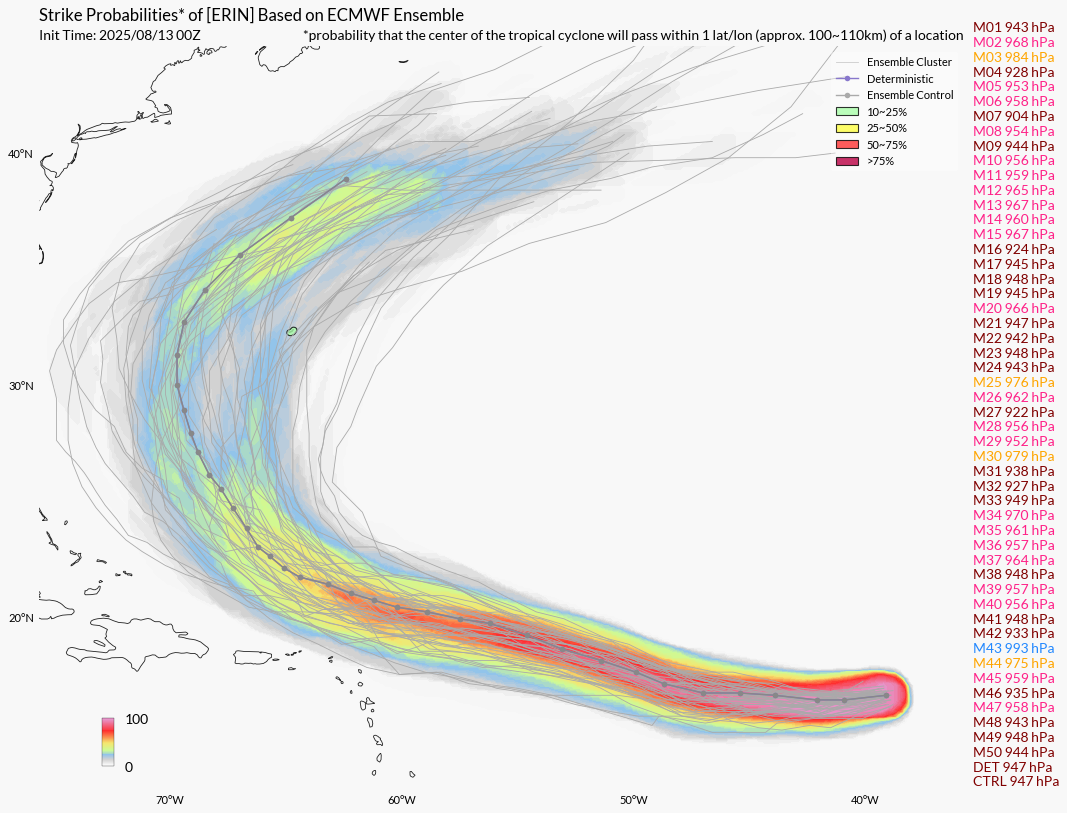
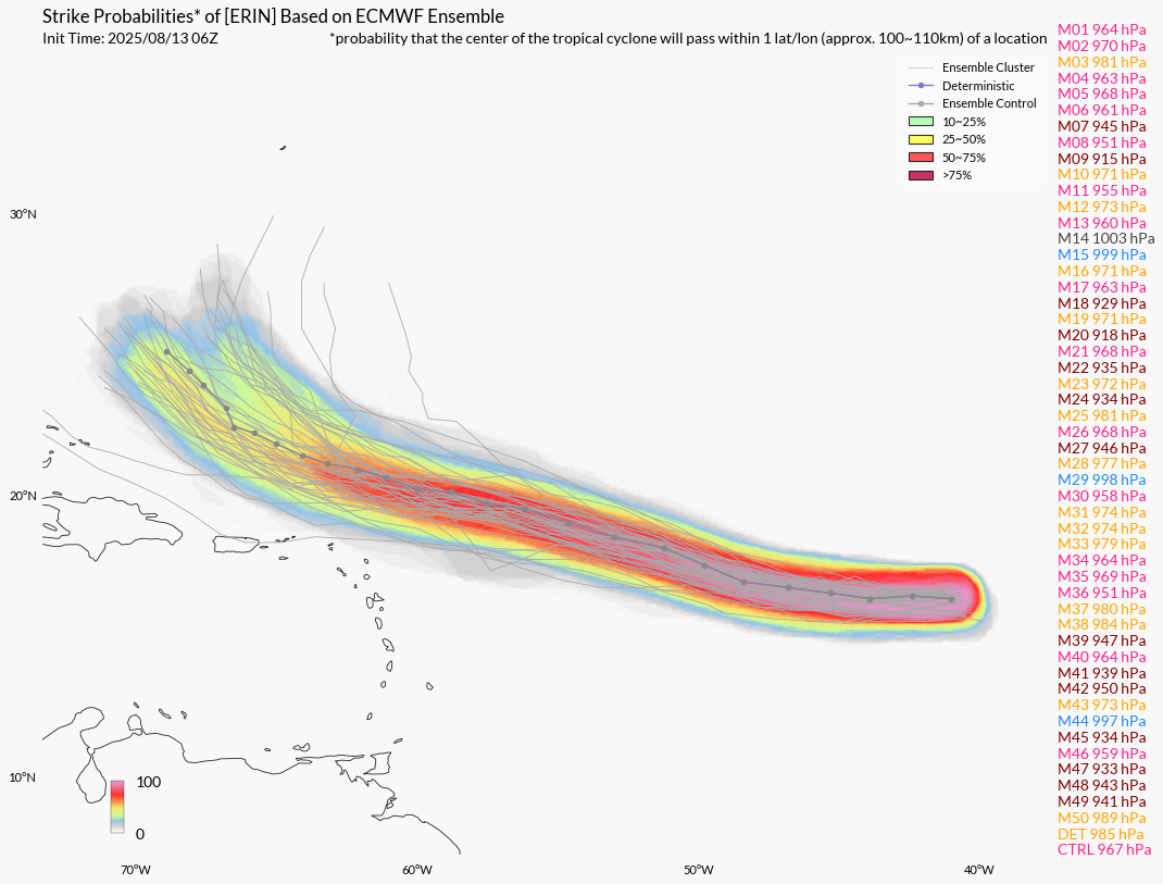
It should be noted that the directional spread becomes very large
in both the deterministic and ensemble track guidance at long range.
Therefore, there is a greater than normal uncertainty about what
impacts Erin may bring to portions of the Bahamas, the east coast
of the United States, and Bermuda.
KEY MESSAGES:
1. Locally heavy rainfall, high surf and rip currents, and
tropical-storm force winds could occur in portions of the northern
Leeward Islands, the Virgin Islands, and Puerto Rico this weekend as
the core of Erin passes north of those islands. Interests in these
areas should continue to monitor the progress of Erin.
2. While there is still uncertainty in what impacts might occur in
portions of the Bahamas, the east coast of the United States, and
Bermuda next week, the risk of dangerous surf and rip currents
across the western Atlantic basin next week is increasing. As we
approach the climatological peak of the hurricane season, this is an
opportune time to ensure your preparedness plans are in place.
FORECAST POSITIONS AND MAX WINDS
INIT 13/2100Z 16.3N 45.0W 45 KT 50 MPH
12H 14/0600Z 16.3N 47.2W 50 KT 60 MPH
24H 14/1800Z 16.9N 50.1W 55 KT 65 MPH
36H 15/0600Z 17.6N 53.0W 65 KT 75 MPH
48H 15/1800Z 18.4N 55.9W 75 KT 85 MPH
60H 16/0600Z 19.3N 58.8W 85 KT 100 MPH
72H 16/1800Z 20.2N 61.4W 95 KT 110 MPH
96H 17/1800Z 22.2N 65.8W 100 KT 115 MPH
120H 18/1800Z 24.8N 68.2W 105 KT 120 MPH
$$
Forecaster Beven
|
本帖子中包含更多资源
您需要 登录 才可以下载或查看,没有账号?立即注册
×
|


 发表于 2025-8-13 17:10