找回密码
 立即注册
搜索
查看: 3037|回复: 93

[快速加强] 牙买加东南四级飓风“梅利莎”(13L.Melissa) - 快速加强,强势威胁牙买加 - NHC:120KT

[复制链接]

15

主题

89

回帖

1753

积分

强热带风暴

积分
1753
发表于 2025-10-18 23:00 | 显示全部楼层 |阅读模式
本帖最后由 hei 于 2025-10-26 17:12 编辑
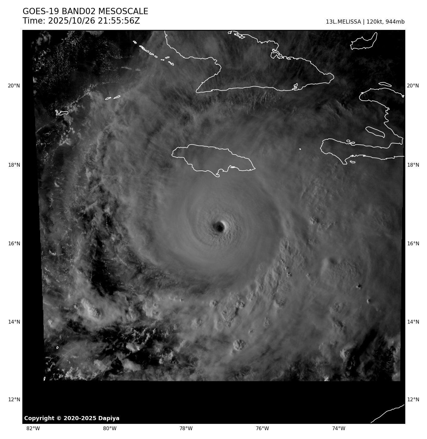
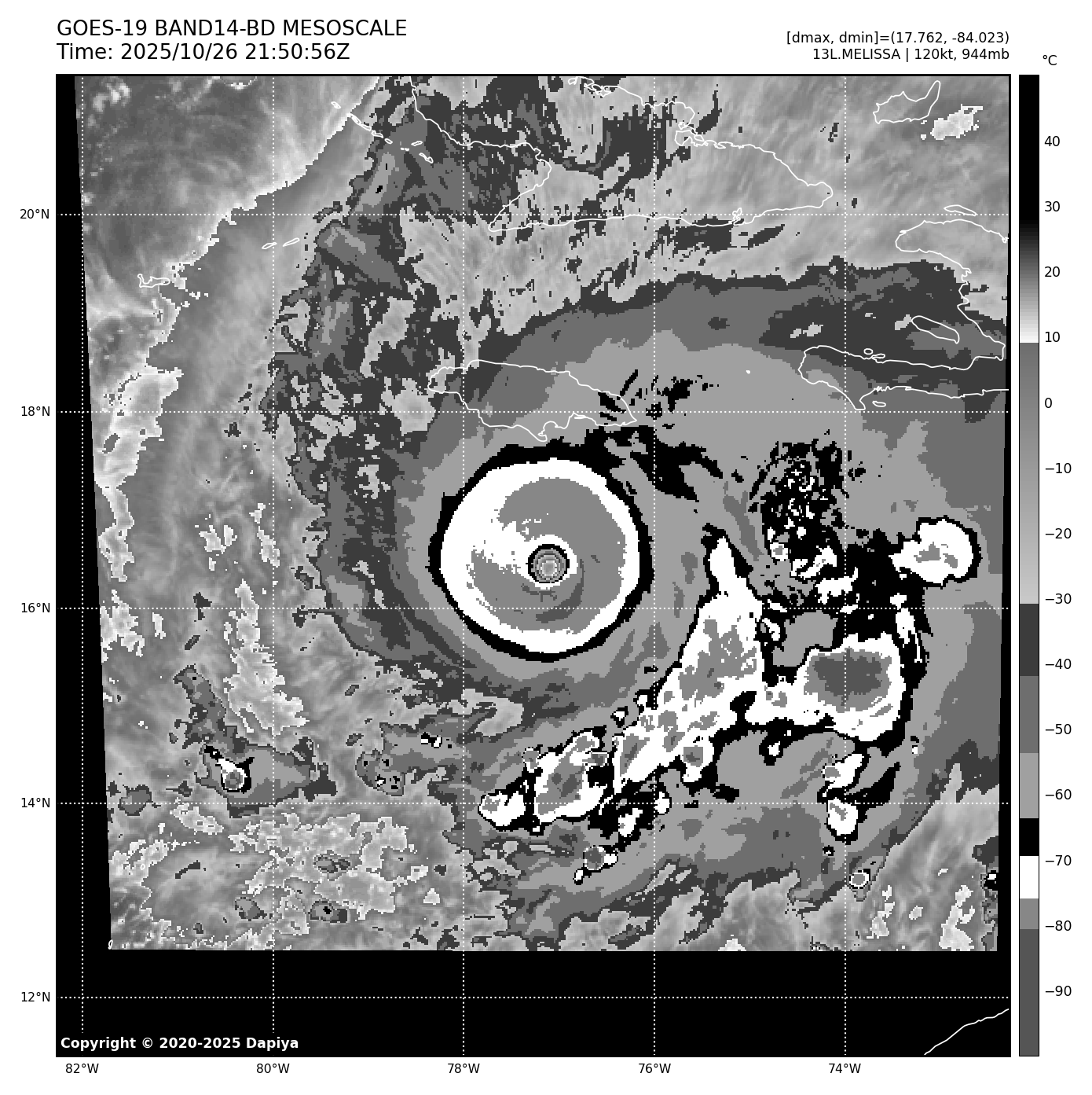
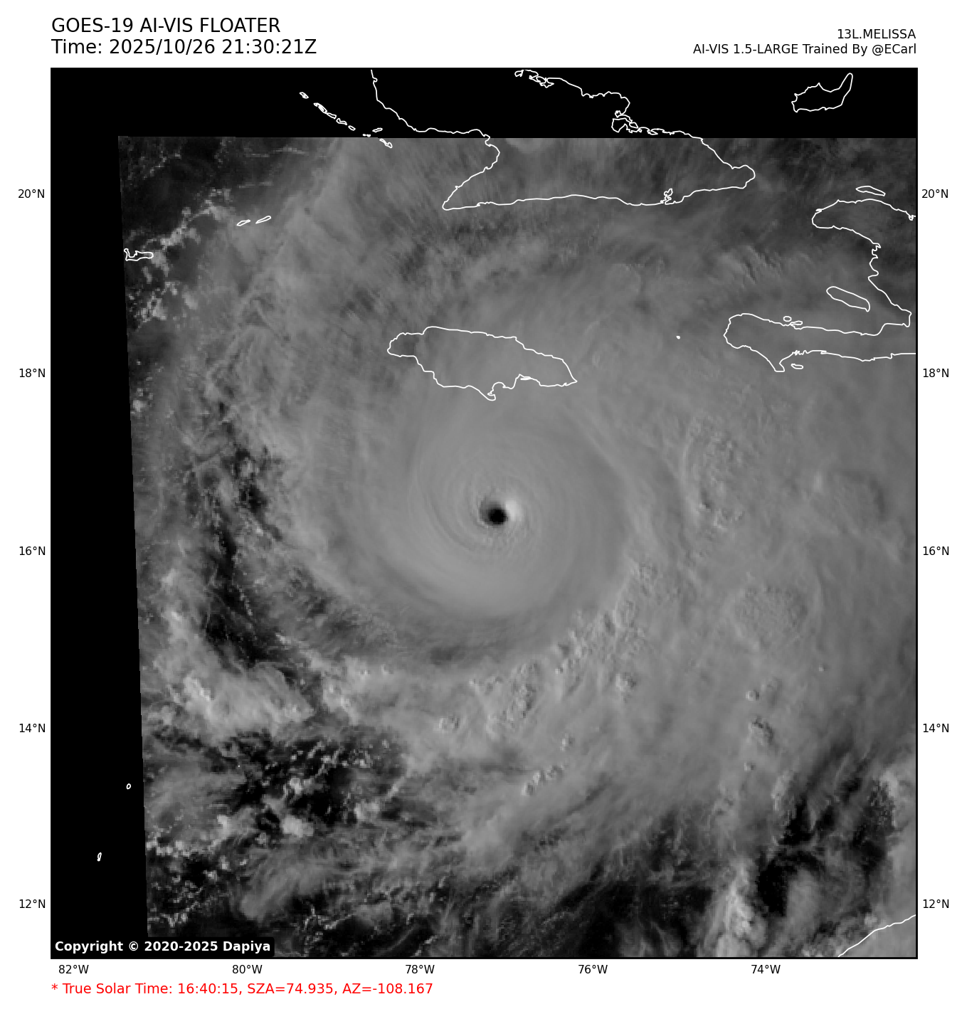
实时云图


编扰资讯
AL, 98, 2025101812,   , BEST,   0, 117N,  499W,  30, 1011, DB


1. East of the Windward Islands and the Caribbean Sea:
A tropical wave located about 800 miles east of the Windward Islands
continues to produce a large area of showers and thunderstorms.  
Gradual development of this system is possible during the next
several days while it moves generally westward at around 20 mph.  
Regardless of development, this system is expected to bring heavy
rainfall and gusty winds to the Windward Islands Sunday and Sunday
night, then move across the Caribbean Sea through much of next week.
* Formation chance through 48 hours...low...near 0 percent.
* Formation chance through 7 days...low...30 percent.

本帖子中包含更多资源

您需要 登录 才可以下载或查看,没有账号?立即注册

×

评分

参与人数 1金钱 +3 威望 +3 收起 理由
yhh + 3 + 3

查看全部评分

130

主题

1万

回帖

5万

积分

世纪风王

积分
57552
发表于 2025-10-19 04:45 | 显示全部楼层
000
ABNT20 KNHC 181751
TWOAT

Tropical Weather Outlook
NWS National Hurricane Center Miami FL
200 PM EDT Sat Oct 18 2025

For the North Atlantic...Caribbean Sea and the Gulf of America:

East of the Windward Islands and the Caribbean Sea (AL98):
A tropical wave located several hundred miles east of the Windward
Islands continues to produce a broad area of showers and
thunderstorms. Earlier satellite wind data indicated the system
lacks a closed circulation, but is producing winds of 30 to 35 mph
to the north of the wave axis. Environmental conditions appear
marginally conductive for slow development over the next couple of
days as the system moves quickly westward at 20 to 25 mph, crossing
the Windward Islands and entering the Caribbean Sea by early next
week. By the middle of next week, the system is expected to slow
down over the central Caribbean Sea, where environmental conditions
could become more favorable for further development. Regardless of
development, this system is expected to bring heavy rainfall and
gusty winds to the Windward Islands Sunday and Sunday night.
* Formation chance through 48 hours...low...10 percent.
* Formation chance through 7 days...low...30 percent.

North Atlantic:
A non-tropical area of low pressure is located several hundred miles
northeast of Bermuda.  There is a slight chance that the system
could develop some subtropical characteristics over the next day or
so before it turns northeastward into cooler ocean waters on Sunday.
* Formation chance through 48 hours...low...10 percent.
* Formation chance through 7 days...low...10 percent.

$$
Forecaster Papin


本帖子中包含更多资源

您需要 登录 才可以下载或查看,没有账号?立即注册

×

130

主题

1万

回帖

5万

积分

世纪风王

积分
57552
发表于 2025-10-19 08:00 | 显示全部楼层
218
ABNT20 KNHC 182341
TWOAT

Tropical Weather Outlook
NWS National Hurricane Center Miami FL
800 PM EDT Sat Oct 18 2025

For the North Atlantic...Caribbean Sea and the Gulf of America:

East of the Windward Islands and the Caribbean Sea (AL98):
A tropical wave located several hundred miles east of the Windward
Islands continues to produce a broad area of showers and
thunderstorms.  This system is expected to move quickly westward at
20 to 25 mph, crossing the Windward Islands during the next day or
so.  By the middle to latter part of next week, environmental
conditions could become more favorable for development, and a
tropical depression could form while the system slows down over the
central Caribbean Sea. Regardless of development, this system is
expected to bring heavy rainfall and gusty winds to the Windward
Islands Sunday into Monday morning.
* Formation chance through 48 hours...low...10 percent.
* Formation chance through 7 days...medium...40 percent.

North Atlantic:
A non-tropical, complex area of low pressure is located several
hundred miles northeast of Bermuda.  Further development of this
system is not expected due to cooling ocean waters while it moves
northeastward over the North Atlantic.
* Formation chance through 48 hours...low...near 0 percent.
* Formation chance through 7 days...low...near 0 percent.

$$
Forecaster Bucci/Reinhart


本帖子中包含更多资源

您需要 登录 才可以下载或查看,没有账号?立即注册

×

32

主题

5930

回帖

1万

积分

超强台风

Super Typhoon

积分
12094
发表于 2025-10-19 13:40 | 显示全部楼层
ZCZC MIATWOAT ALL
TTAA00 KNHC DDHHMM

Tropical Weather Outlook
NWS National Hurricane Center Miami FL
200 AM EDT Sun Oct 19 2025

For the North Atlantic...Caribbean Sea and the Gulf of America:

1. East of the Windward Islands and the Caribbean Sea (AL98):
A tropical wave located a couple of hundred miles east of the
Windward Islands is producing a large and persistent area of showers
and thunderstorms.  Recent satellite-derived wind data indicate that
the system still lacks a closed circulation, but is producing winds
of 30 to 35 mph north and east of the wave axis.  Environmental
conditions are expected to limit development during the next couple
of days as the system moves quickly westward at 20 to 25 mph,
bringing heavy rainfall and gusty winds to the Windward Islands
beginning later today and continuing through Monday morning.  By the
middle to latter part of the week, environmental conditions are
forecast to become more conducive for development, and a tropical
depression could form while the system slows down over the central
Caribbean Sea.
* Formation chance through 48 hours...low...10 percent.
* Formation chance through 7 days...medium...50 percent.


Forecaster Jelsema

本帖子中包含更多资源

您需要 登录 才可以下载或查看,没有账号?立即注册

×
P

130

主题

1万

回帖

5万

积分

世纪风王

积分
57552
发表于 2025-10-19 20:00 | 显示全部楼层
000
ABNT20 KNHC 191144
TWOAT

Tropical Weather Outlook
NWS National Hurricane Center Miami FL
800 AM EDT Sun Oct 19 2025

For the North Atlantic...Caribbean Sea and the Gulf of America:

Near the Windward Islands and the Caribbean Sea (AL98):
A tropical wave currently located near the Windward Islands is
producing a large area of showers and thunderstorms. Heavy rainfall
and gusty winds are expected today continuing through Monday morning
across portions of the Windward and Leeward Islands as the system
moves quickly westward at 20 to 25 mph into the eastern Caribbean
Sea. Additional development is forecast to be limited over the next
day or two, due to the fast forward motion of the wave. The system
is then expected to slow down over the central Caribbean Sea during
the middle portion of the week, where environmental conditions could
become more conducive for development. A tropical depression could
from over the central Caribbean Sea by the middle to latter portion
of this week.
* Formation chance through 48 hours...low...10 percent.
* Formation chance through 7 days...medium...60 percent.

$$
Forecaster Papin


本帖子中包含更多资源

您需要 登录 才可以下载或查看,没有账号?立即注册

×

130

主题

1万

回帖

5万

积分

世纪风王

积分
57552
发表于 2025-10-20 04:55 | 显示全部楼层
000
ABNT20 KNHC 191738
TWOAT

Tropical Weather Outlook
NWS National Hurricane Center Miami FL
200 PM EDT Sun Oct 19 2025

For the North Atlantic...Caribbean Sea and the Gulf of America:

Near the Windward Islands and the Caribbean Sea (AL98):
Recent satellite wind data and surface observations indicate the
tropical wave currently crossing the Windward Islands still lacks a
closed circulation. However both radar and satellite images indicate
the associated shower and thunderstorm activity is starting to show
signs of organization. The system is still moving quickly westward
at 20 to 25 mph, which could limit development over the next day or
so, but environmental conditions are forecast to become more
favorable as it slows down in the central Caribbean Sea by the
middle of this week. A tropical depression is likely to form by the
middle to latter portion of this week in the central Caribbean Sea.
Regardless of development, heavy rainfall and gusty winds are
expected to continue for portions of the Windward and Leeward
Islands through Monday morning.
* Formation chance through 48 hours...low...30 percent.
* Formation chance through 7 days...high...70 percent.

$$
Forecaster Papin


本帖子中包含更多资源

您需要 登录 才可以下载或查看,没有账号?立即注册

×

32

主题

5930

回帖

1万

积分

超强台风

Super Typhoon

积分
12094
发表于 2025-10-20 13:45 | 显示全部楼层
ZCZC MIATWOAT ALL
TTAA00 KNHC DDHHMM

Tropical Weather Outlook
NWS National Hurricane Center Miami FL
200 AM EDT Mon Oct 20 2025

For the North Atlantic...Caribbean Sea and the Gulf of America:

1. Caribbean Sea (AL98):
A tropical wave located over the eastern Caribbean Sea, a few
hundred miles west of the Windward Islands, is producing a large
area of poorly organized showers and thunderstorms.  Recent
satellite-derived wind data indicate that the disturbance continues
to lack a closed circulation, although it is producing winds of 30
to 40 mph to the north and east of the wave axis.  The system is
moving quickly westward at 20 to 25 mph, which should limit
significant development during the next day or so.  Thereafter,
environmental conditions are expected to become more conducive for
development as the wave slows down over the central Caribbean Sea,
and a tropical depression is likely to form during the middle to
latter part of this week.  Regardless of development, heavy rainfall
and gusty winds are expected to continue affecting portions of the
Windward and Leeward Islands this morning.
* Formation chance through 48 hours...low...30 percent.
* Formation chance through 7 days...high...70 percent.


Forecaster Jelsema

本帖子中包含更多资源

您需要 登录 才可以下载或查看,没有账号?立即注册

×
P

130

主题

1万

回帖

5万

积分

世纪风王

积分
57552
发表于 2025-10-20 20:00 | 显示全部楼层
000
ABNT20 KNHC 201148
TWOAT

Tropical Weather Outlook
NWS National Hurricane Center Miami FL
800 AM EDT Mon Oct 20 2025

For the North Atlantic...Caribbean Sea and the Gulf of America:

Caribbean Sea (AL98):
A tropical wave located over the eastern Caribbean Sea is producing
a concentrated area of showers and thunderstorms primarily east of
the wave axis. The system is moving westward at 15 to 20 mph towards
the central Caribbean Sea and is expected to slowdown over the next
few days. Environmental conditions are forecast to become more
conducive for development, and a tropical depression or storm is
likely to form over the next few days. Regardless of development,
heavy rainfall and gusty winds are subsiding for the Windward and
Leeward Islands this morning, but could begin over portions of the
ABC Islands during the next couple of days. For more information on
this system, including Gale Warnings, please see High Seas Forecasts
issued by the National Weather Service.
* Formation chance through 48 hours...medium...50 percent.
* Formation chance through 7 days...high...80 percent.

&&
High Seas Forecasts issued by the National Weather Service
can be found under AWIPS header NFDHSFAT1, WMO header FZNT01
KWBC, and online at ocean.weather.gov/shtml/NFDHSFAT1.php

$$
Forecaster Papin


本帖子中包含更多资源

您需要 登录 才可以下载或查看,没有账号?立即注册

×

130

主题

1万

回帖

5万

积分

世纪风王

积分
57552
发表于 2025-10-21 04:25 | 显示全部楼层
006
ABNT20 KNHC 201739
TWOAT

Tropical Weather Outlook
NWS National Hurricane Center Miami FL
200 PM EDT Mon Oct 20 2025

For the North Atlantic...Caribbean Sea and the Gulf of America:

Caribbean Sea (AL98):
Recent satellite wind data indicate the tropical wave located over
the eastern Caribbean Sea still lacks a closed circulation, but
continues to produce a concentrated area of showers and
thunderstorms near and to the east of the wave axis. Compared to
yesterday, surface observations suggest the circulation is gradually
becoming better defined, and environmental conditions are forecast
to become a little more conducive for development as the system
slows its forward motion. A tropical depression or storm is now
likely to form over the next day or two as it moves into the central
Caribbean Sea. Regardless of development, heavy rainfall and gusty
winds are possible over portions of the ABC Islands during the next
couple of days. Interests in Puerto Rico, Hispaniola, Jamaica, and
Cuba should monitor its progress as there is a risk of heavy rain
and flooding, strong winds, and rough surf later this week. For
addition information on this system, including Gale Warnings, please
see High Seas Forecasts issued by the National Weather Service.
* Formation chance through 48 hours...high...70 percent.
* Formation chance through 7 days...high...90 percent.

&&
High Seas Forecasts issued by the National Weather Service
can be found under AWIPS header NFDHSFAT1, WMO header FZNT01
KWBC, and online at ocean.weather.gov/shtml/NFDHSFAT1.php

$$
Forecaster Papin


本帖子中包含更多资源

您需要 登录 才可以下载或查看,没有账号?立即注册

×

143

主题

1万

回帖

4万

积分

论坛版主-副热带高压

明天见,是最伟大的预言

积分
48550
发表于 2025-10-21 05:45 | 显示全部楼层


WTNT21 KNGU 202000
SUBJ/TROPICAL CYCLONE FORMATION ALERT//
REF/A/FLTWEACEN NORFOLK VA/202000Z OCT 25//
AMPN/REF IS TROPICAL CYCLONE FORMATION ALERT (98L) CORRECTED//
RMKS/1. CORRECTED TO ADD 98L IN THE AMPN/REF LINE.
2. FORMATION OF A SIGNIFICANT TROPICAL CYCLONE IS POSSIBLE
WITHIN 100 NM EITHER SIDE OF A LINE FROM 13.8N 68.0W TO 14.2N 74.2W
WITHIN THE NEXT 24 HOURS. AVAILABLE DATA DOES NOT JUSTIFY
ISSUANCE OF NUMBERED TROPICAL CYCLONE WARNINGS AT THIS TIME.
WINDS IN THE AREA ARE ESTIMATED TO BE 30 TO 40 KNOTS. METSAT
IMAGERY AT 201800Z INDICATES THAT A CIRCULATION CENTER IS LOCATED
NEAR 13.9N 68.0W. THE SYSTEM IS MOVING WESTWARD AT 15 KNOTS.
3. A BROAD LOW PRESSURE SYSTEM ASSOCIATED WITH TROPICAL WAVE IS
LOCATED IN THE EASTERN CARIBBEAN SEA, 141NM NORTHEAST FROM ARUBA.
CIRCULATION IS GRADUALLY BECOMING A LITTLE MORE CONDUCIVE FOR
DEVELOPMENT. THE POTENTIAL FOR THE DEVELOPMENT OF A SIGNIFICANT
TROPICAL CYCLONE WITHIN THE NEXT 24 HOURS IS HIGH. THIS SUPERSEDES
REF A.
4. THIS ALERT WILL BE REISSUED, SUPERSEDED BY POTENTIAL TROPICAL
CYCLONE ADVISORY, UPGRADED TO WARNING, OR CANCELLED BY 212000Z.//

本帖子中包含更多资源

您需要 登录 才可以下载或查看,没有账号?立即注册

×


生命因何而沉睡,因为总有一天我们会从梦中醒来
您需要登录后才可以回帖 登录 | 立即注册

本版积分规则

QQ|Archiver|手机版|小黑屋|TY_Board论坛

GMT+8, 2025-10-27 06:51 , Processed in 0.060746 second(s), 21 queries .

Powered by Discuz! X3.5

© 2001-2025 Discuz! Team.

快速回复 返回顶部 返回列表